| CROSSDRIVE HDF5 Data Format |
|
|
|
|
|
|
|
|
|
|
|
|
|
|
|
|
|
|
|
|
|
|
|
| Description
of the files used to store ExoMars TGO NOMAD data. |
|
|
| Document change record |
|
| Issue/
revision |
Issue/ revision date |
Reason for change |
Fields added |
Fields modified |
|
| 0/0 |
|
Document creation |
All |
N/A |
|
| 0/7 |
25/11/2015 |
Addition of document change record. Various
confusing field names changed and addition of a new field |
LSubS (areocentric longitude) |
SSLat becomes SubSatLat |
|
| SSLon
becomes SubSatLon |
|
| LSubS
becomes SubSolLon |
|
| LatSubS
becomes SubSolLat |
|
| 0/8 |
26/11/2015 |
Addition of geometry
diagram. |
N/A |
N/A |
|
| 0/9 |
03/12/2015 |
Added Extra
UVIS Params in Channel S3. Updated various descriptions. Lon/lat changed. |
CornerLatitude |
Lat becomes CentreLat |
|
| Added quality flag table and descriptions of additional
housekeeping and UVIS
extra parameters fields |
CornerLongitude |
Lon becomes CentreLon |
|
| 0/11 |
31/12/2015 |
Checking the file format wrt ASIMUT |
|
Added the size of the matrices |
|
|
| 0/12 |
07/01/2016 |
Checking the file format wrt
ASIMUT |
|
Moved NBin, Xtype, YType,
XUnits, YUnits from ‘DataSets’ to
‘Attributes’ |
|
| 0/17 |
09/02/2016 |
Made lots of changes to Geometry
(added point groups) and Science fields. Quality flags slightly modified |
Point groups (geometry),
SpectralCoefficients (Science), Cosmic Ray Disturbance quality flag |
Deleted XNb and XTypeFlag |
|
|
|
|
|
|
|
|
|
|
|
|
|
|
|
|
|
|
|
|
| 0/18 |
16/02/2016 |
Various addtions, changes to
match compability with PSA and Asimut |
Mission Phase, Diffraction Order |
All names modified to remove
underscores |
|
|
|
|
|
|
|
|
|
|
|
|
|
|
|
|
|
|
|
|
| 0/19 |
07/03/2016 |
Various addtions, changes to
match compability with PSA and Asimut |
ReliefAlt, SpectralResolution,
SpectralResolutionFlag, AOTFTuningFunction, AOTFWavenumberCoefficients,
WavenumberAOTFCoefficients, GeometryPoints |
TangentAlt, Geometry, AOTF, LST,
Target |
|
|
|
|
|
|
|
|
|
|
|
|
|
|
|
|
|
|
|
|
| 0/22 |
15/03/2016 |
Various addtions, changes to
match compability with PSA and Asimut |
|
|
|
|
|
|
|
|
|
|
|
|
|
|
|
|
|
|
|
|
|
|
| 0/27 |
12/04/2018 |
Add Goddard spectral calibration
results |
OrderAOTFCoefficients,
AOTFOrderCoefficients, |
AOTFBandwidth+Flag,
BlazeFunction+Flag |
|
|
|
|
|
|
|
|
|
|
|
|
|
|
|
|
|
|
|
|
|
|
|
|
| General File Structure |
|
| Each HDF5
file contains attributes that provide an overview of the file and measurement
made. Each is composed of a single value, vector or string |
|
| Each HDF5
file contains many datasets |
|
| Each dataset
can contain a single field or a set of fields. For datasets with multiple
fields, there is typically one dataset listing the field names, one for the
units, and one for the data itself |
|
|
| Data
Types: (possibly not yet implemented consistently throughout) |
|
| [L]
= Longword integer: 32-bit (4 bytes) signed integer; |
|
| [D]
= Double-precision floating: 64-bit (8 bytes), double-precision,
floating-point number; |
|
| [F]
= Floating-point: 32-bit (4 bytes), single-precision, floating-point number. |
|
| When
a parameter is not known or not relevant, use: |
|
| · "-999" if the parameter is of type integer |
|
| · "-999.0" if the parameter is of type float |
|
| · "N/A" if the parameter is of type string |
|
|
|
| File Names: |
|
| For
calibration, HDF5 calibration filenames are of the form: |
|
| yyyymmdd_hhmmss_c_x.h5 |
|
| E.g. 20150402_133845_LNO_1.h5 |
|
| For
ground operations, HDF5 calibration filenames are copied from the PSA tab or
EDDS raw file that the data was extracted from. |
|
|
|
|
| |
|
|
|
|
|
|
|
|
|
|
|
|
|
|
|
|
|
|
|
|
|
|
|
|
|
|
|
|
|
|
|
|
|
|
|
|
|
|
|
|
|
|
|
|
|
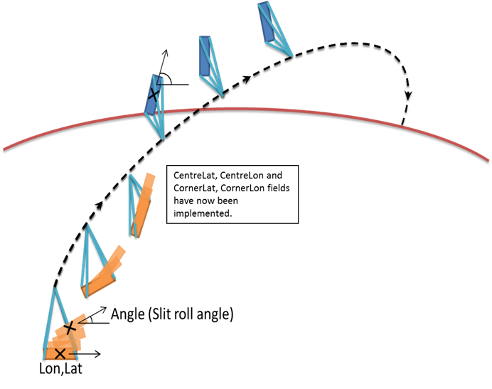
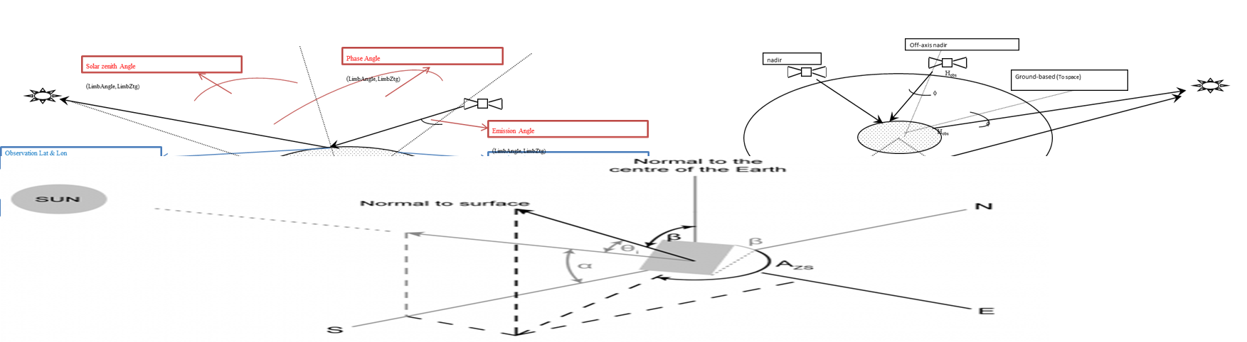
| Emission Angle |
|
| Measured
from the center of the image, this is the angle between the instrument LOS
and a "normal" drawn perpendicular to the planet's surface. When
the instrument is looking straight down ("nadir"), the emission
angle is 0°. |
|
| Phase Angle |
|
| This
is the angle between the sun, the surface, and the HiRISE camera at the time
the picture was obtained. |
|
| Solar Incidence Angle |
|
| Derived
for the center of the image, this is the angle between the Sun and a
"normal" drawn perpendicular to the planet's surface at the time the observation was acquired. A higher incidence
angle means that a person standing on the ground would see the sun lower
toward the horizon. |
|
| Difference
between Solar Zenith Angle and Solar Incidence Angle: |
|
| Where b is the angle of inclination of the surface from the horizontal |
|
| Incidence
Angle = Solar Zenith Angle only if surface is flat ( b = 0) |
|
|
|
|
| Solar Longitude (Mars) |
|
| Commonly
referred to as Ls (pronounced "L sub S"), this is the position of
Mars relative to the Sun measured in degrees from the vernal equinox (start
of northern Spring). This number is used as a measure of Martian seasons:
Northern Spring/Southern Autumn start at 0°, Northern Summer/Southern Winter
start at 90°, Northern Autumn/Southern Spring start at 180°, and Northern
Winter/Southern Summer begin at 270°. |
|
|
|
|
|
|
|
|
|
|
|
|
|
|
|
|
|
|
|
|
|
|
|
|
|
|